Anchorage
Fiji
Depth
16.0 ft
5.0 m
Bottom Composition
Co - Coral
S - Sand
Aids to Navigation
Depth Contours
Land
Shore Access
Beach
Notes

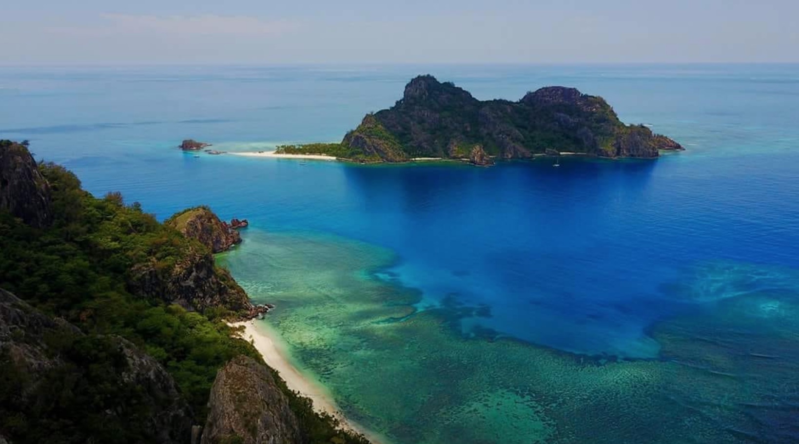
Great deserted Island with wild goats - do not anchor if swell forcasts are over 1.5 meters as they will wrap around and make it rolly - to land the dinghy safely look for the sand spit and find the rocks that are between the westernmost hill and the central hill - you will see some rocks - these rocks ( on the sand spit ) are your marker - guide the dinghy just to the left of these rocks - for a smooth rising beach - the main island has a very steep beach and some experienced cruisers and mariners have flipped their dinghies !

Wind Exposure
N SE NW
Swell Exposure
N NW
Date & Time Visited
2014-07-01T08:13:00
editor
Anchorage
Fiji
Depth
56.0 ft
17.0 m
Bottom Composition
S - Sand
Co - Coral
Aids to Navigation
Depth Contours
Land
Shore Access
Beach
Notes

Nice Beach

Wind Exposure
N SE W NW
Swell Exposure
N NW
Date & Time Visited
2013-12-03T09:45:00
editor
Anchorage
Fiji
Depth
108.0 ft
33.0 m
Bottom Composition
S - Sand
Co - Coral
Aids to Navigation
Land
Depth Contours
Shore Access
Beach
Wind Exposure
E SE S W NW
Swell Exposure
E SE S W NW
Date & Time Visited
2014-01-06T11:00:00
editor
Anchorage
Fiji
Depth
52.0 ft
15.5 m
Bottom Composition
S - Sand
Aids to Navigation
Depth Contours
Land
Shore Access
Beach
Wind Exposure
N NE E SE S W NW
Swell Exposure
N NE E SE S W NW
Date & Time Visited
2011-05-03T11:30:00
editor
Anchorage
Fiji
Approach
◬ 17° 36.6131 S 177° 3.0630 E
◬ 17° 36.4707 S 177° 2.8944 E
◬ 17° 36.3578 S 177° 2.6549 E
◬ 17° 36.3566 S 177° 2.4425 E
◬ 17° 36.4180 S 177° 2.3923 E
◬ 17° 36.4756 S 177° 2.3678 E
◬ 17° 36.4904 S 177° 2.3704 E
Depth
28.0 ft
8.5 m
Bottom Composition
Co - Coral
S - Sand
Aids to Navigation
Land
Depth Contours
Shore Access
Beach
Wind Exposure
N NE E SE NW
Swell Exposure
N NE E SE NW
Date & Time Visited
2011-09-09T15:00:00
editor
Anchorage
Australia - Queensland
Depth
44.0 ft
13.0 m
Bottom Composition
Co - Coral
S - Sand
Aids to Navigation
Depth Contours
Land
Shore Access
Beach
Notes
Wind Exposure
N NE S SW W NW
Swell Exposure
N NE S SW W NW
Date & Time Visited
2011-08-01T12:48:00
editor
Anchorage
Australia - Queensland
Depth
35.0 ft
10.5 m
Bottom Composition
Co - Coral
S - Sand
Aids to Navigation
Depth Contours
Land
Shore Access
Beach
Wind Exposure
N NE E SE S SW W NW
Swell Exposure
N NE E SE S SW W NW
Date & Time Visited
2002-06-24T11:22:00
editor
Anchorage
Australia - Queensland
Depth
39.0 ft
11.5 m
Bottom Composition
Co - Coral
S - Sand
Aids to Navigation
Land
Depth Contours
Shore Access
Tidal Reef
Wind Exposure
N NE E S SW W NW
Swell Exposure
N NE E S SW W NW
Date & Time Visited
2011-08-02T11:54:00
editor
Anchorage
Australia - Queensland
Depth
21.0 ft
6.0 m
Bottom Composition
M - Mud
S - Sand
Aids to Navigation
Channel Marks
Depth Contours
Land
Shore Access
Boat Ramp
Floating Dock
Notes

Most convenient anchorage for access to the mainland and Westport from Clew Bay. Mayo Sailing Club is only open when there is racing and or instruction. When open, it has a bar and wifi. The pontoon is for short term tie up only. Taxi service is available to Westport town which is a great holiday destination. The MSC mooring field consists of trots. There is a great deal of gear in the anchorage from which Adventure Islands operates. Take care to avoid obstructions.

Date & Time Visited
2014-07-18T15:02:00
editor
Anchorage
Australia - Queensland
Depth
17.0 ft
5.0 m
Bottom Composition
Co - Coral
S - Sand
Aids to Navigation
Depth Contours
Land
Shore Access
Tidal Reef
Wind Exposure
N NE E S SW W NW
Swell Exposure
N NE E S SW W NW
Date & Time Visited
2011-08-12T12:02:00
editor