Anchorage
Mexico - Pacific
Approach
◬ 24° 31.4079 N 110° 24.9207 W
◬ 24° 31.7686 N 110° 22.9689 W
◬ 24° 31.7827 N 110° 22.5517 W
◬ 24° 31.7007 N 110° 22.4771 W
Depth
18.0 ft
5.0 m
Bottom Composition
S - Sand
Aids to Navigation
Depth Contours
Land
Shore Access
Beach
Notes

The anchorage on the southern side of Caleta Partida is sheltered to weather from the south but exposed to wind and swell from the north or west as well as easterly winds.

Approaches

No info

Anchorage

Anchor in 5m on sand. This anchorage may be rolly in a northerly swell. Dinghy ashore to explore the sand spit or dinghy through the channel known as Sandbar Pass to the east coast.

Facilities

None.

Dangers
Squalls
Wind Exposure
N NE E SE S SW W NW
Swell Exposure
N NE E SE S SW W NW
Date & Time Visited
2008-11-23T00:00:00
editor
Anchorage
Mexico - Pacific
Approach
◬ 24° 31.6562 N 110° 25.3841 W
◬ 24° 31.7265 N 110° 22.8504 W
◬ 24° 31.8530 N 110° 22.6290 W
◬ 24° 32.0732 N 110° 22.7062 W
Depth
10.0 ft
3.0 m
Bottom Composition
S - Sand
M - Mud
Aids to Navigation
Depth Contours
Land
Shore Access
Beach
Notes

Caleta Partida lies at the west end of the channel which separates Isla Espiritu Santo from Isla Partida to the north. This big deep bay has space for plenty of boats. A golden beach known as Sandbar Pass almost closes off the bay but the channel winds it’s way through at the southern end of the sand spit.

Caleta Partida offers plenty of action; snorkeling, hiking or exploring the sea caves by dinghy or kayak. Large party boats anchor in this bay so it can get pretty lively.

Approaches

No info

Anchorage

The cove on the north side of the bay offers some protection from coromuels and from the northerly swell which sometimes wraps around the point. The bay is exposed to wind from the east funneling through the channel between the islands.

Facilities

None. Some fishing shacks and a small shrine can be found on the sand spit and it is possible to cross over to the east side of the island by dinghy at high water.

Dangers
Squalls
Wind Exposure
N NE W NW
Swell Exposure
N NE W NW
Date & Time Visited
2013-03-01T12:47:00
editor
Anchorage
Mexico - Pacific
Ensenada de la Ballena
Approach
◬ 24° 27.9540 N 110° 24.7662 W
◬ 24° 28.7907 N 110° 23.7465 W
◬ 24° 29.2160 N 110° 23.5328 W
◬ 24° 29.2488 N 110° 23.4465 W
◬ 24° 29.2523 N 110° 23.3023 W
◬ 24° 29.2371 N 110° 23.2083 W
Depth
14.0 ft
4.0 m
Bottom Composition
S - Sand
Aids to Navigation
Depth Contours
Land
Shore Access
Beach
Notes

This quiet cove on the west coast of Isla Espiritu Santo is sheltered by Isla Ballena offering some protection from northerly wind and swell. 

Approaches

No info

Anchorage

Anchor in the middle of this small cove in 4m on a sandy bottom.

Facilities

None. A hike up the canyon at the back of the beach takes you deep into the centre of  this desert island.

Dangers
Squalls
Wind Exposure
S SW W NW
Swell Exposure
S SW W NW
Date & Time Visited
2008-11-22T16:00:00
editor
Anchorage
Mexico - Pacific
Approach
◬ 24° 33.6916 N 110° 26.2236 W
◬ 24° 33.6752 N 110° 24.9438 W
◬ 24° 33.8157 N 110° 24.3696 W
◬ 24° 33.8321 N 110° 24.1842 W
Depth
18.0 ft
5.0 m
Bottom Composition
S - Sand
Aids to Navigation
Depth Contours
Land
Shore Access
Beach
Notes

This anchorage lies in a small cove on the east shore of Ensenada Grande. Punta Tintorera provides protection from wind and swell from the north but the bay is open to the west and southwest.

Approaches

No info

Anchorage

As the cove is shallow anchor at the mouth of the bay in 5m on sand.

Facilities

None.

Wind Exposure
SW W NW
Swell Exposure
SW W
Date & Time Visited
2009-11-22T11:24:00
editor
Anchorage
Mexico - Pacific
Depth
21.0 ft
6.0 m
Bottom Composition
S - Sand
Aids to Navigation
Depth Contours
Land
Shore Access
Beach
Notes

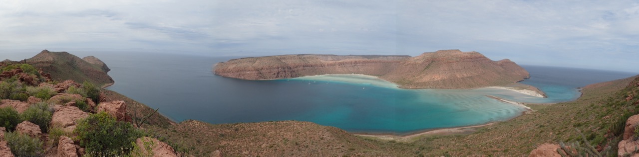
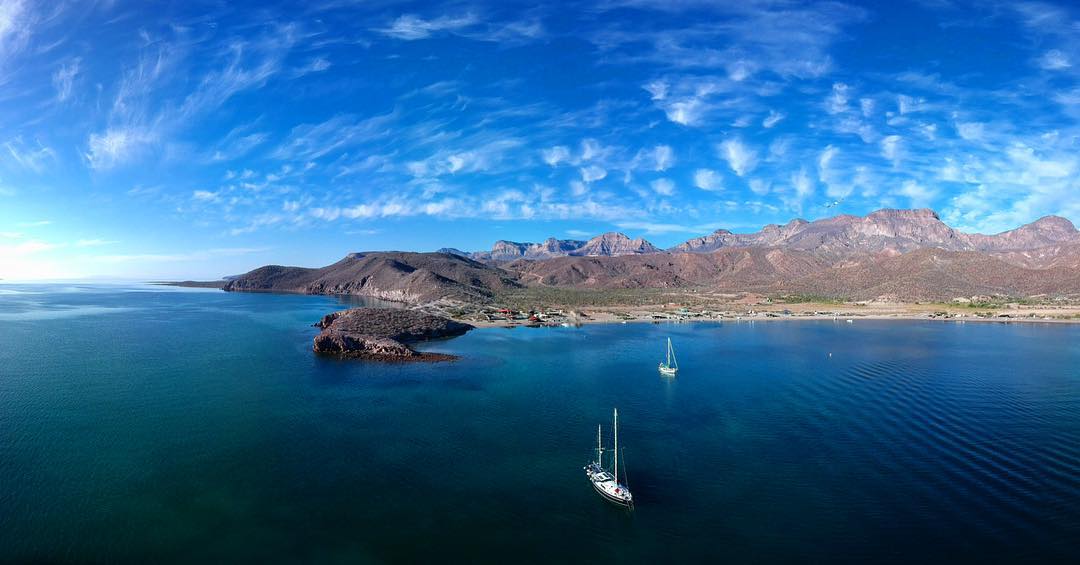
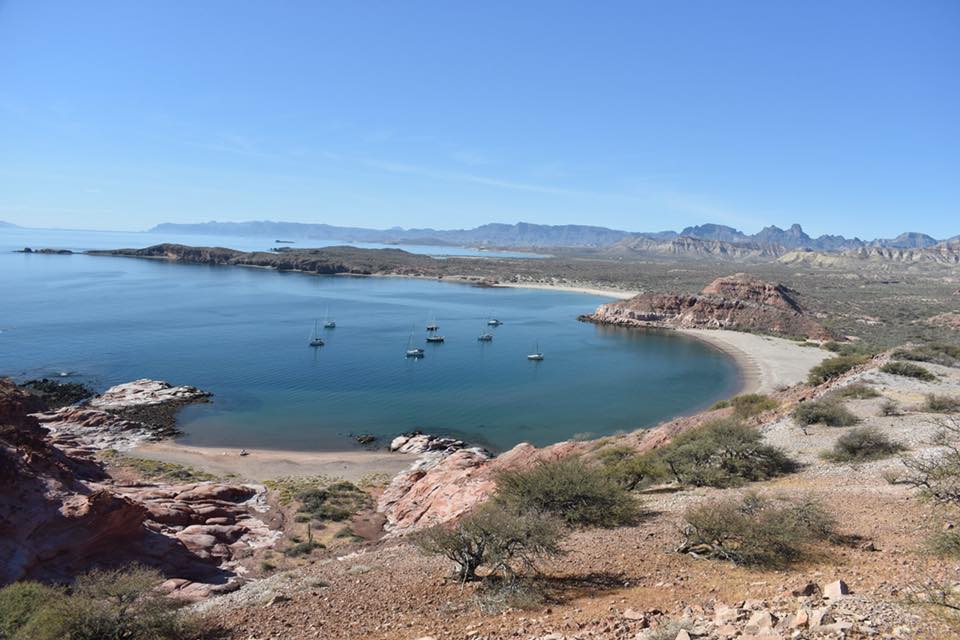
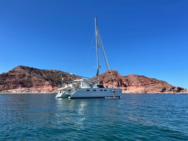
Isla San Francisco is a small island located just south of Isla San Jose, 17NM NNW of Isla Partida. The anchorage is straight out of a travel brochure: a perfect crescent shaped bay lined with aquamarine water, white sand and craggy red rocks dotted with cactus. It is a popular location with locals, especially at weekends or holidays but the Bahia San Francisco is large enough to hold 15-20 boats. The tour boats anchor behind the hook but anchorage can be taken anywhere in the bay.

The bay is exposed to winds from the northeast which blow straight across the sand bar and some swell wraps around into the bay. It is well sheltered from northerlies and their associated swell but is not recommended if a coromuel is predicted.

Approaches

No info

Anchorage

The east side of the bay is slightly better protected from the swell but exposed to tour boats and beach parties. Anchor on the west side of the bay for a quieter experience in 6m on sand with great holding. Dinghy ashore being careful of the swell on the beach.

Facilities

None. It is a lovely walk across the salt flats to the east side of the island or hike up the well worn track to the top of the rocky tor at the southern end if the island. At weekends it is party-on with catamarans rafted up, tents set up on the beach, dinghies and SUPs flitting between the boats making social calls. Everyone likes to party at Isla San Francisco!

Wind Exposure
NE S SW W
Swell Exposure
S SW W
Date & Time Visited
2009-05-09T07:15:00
editor
Anchorage
Mexico - Pacific
Approach
◬ 24° 52.9479 N 110° 37.1412 W
◬ 24° 53.2656 N 110° 36.1628 W
◬ 24° 53.0601 N 110° 35.4469 W
◬ 24° 52.6863 N 110° 35.0349 W
◬ 24° 52.4060 N 110° 35.0349 W
◬ 24° 52.2238 N 110° 35.1070 W
Depth
38.0 ft
11.5 m
Bottom Composition
S - Sand
Aids to Navigation
Depth Contours
Land
Shore Access
Beach
Notes

Isla San Jose lies off the eastern Baja coast about 50NM north of La Paz. The sand spit around to Punta Ostiones at the southern end of the island provides great shelter from almost any swell. The craggy peaks of Isla San Jose give protection from NE-SE winds but the anchorage is exposed to north winds tend to funnel down the Canal de San Jose.

Tour boats occasionally visit the bay to walk on the beach and snorkel in the crystal clear water, the lush green of the mangroves stands out as a splash of colour against the brown hills. Mosquitos and sand flies can be ferocious but rarely make it out to boats at anchor.

Approaches

No info

Anchorage

Anchorage can be taken on the north or south sides of the bay in 5-10m in sand with good holding. The water in the centre of the bay is a little deeper but there is room in the bay for plenty of boats. Dinghy ashore to the beach to explore the sand spit.

Facilities

None. The sand bars and mangroves provide plenty of opportunity for dinghy exploration. Enter the channel at the north end of the bay, preferably at high tide, and pass through the tunnel of mangrove roots to the tranquil lagoon on the east side of the spit.

Dangers
Mosquitos
Sandflies
Wind Exposure
W NW
Swell Exposure
W NW
Date & Time Visited
2009-05-10T12:01:00
editor
Anchorage
Mexico - Pacific
Bahia Amortajada
Punta Salina
Depth
35.0 ft
10.5 m
Bottom Composition
S - Sand
Aids to Navigation
Depth Contours
Land
Shore Access
Beach
Notes

Bahia Amortajada is the large bay on the southwest side of Isla San Jose bounded by Punta Salina to the north and Punta Ostiones to the south. The anchorage in the lee of Punta Salina is well protected in NW-SE winds but exposed to any swell from the south. In calm conditions or in southerly winds during the wet season anchor on the north side of Punta Salinas.

Isla San Jose is the sixth largest island in Mexico and is uninhabited. The abandoned buildings and rusting equipment at Punta Salina are the remains of an old salt mine and the red and white flats of the salinas stretch out like patchwork across the point behind the ruins.

Approaches

No info

Anchorage

The north side of the bay is steep and the east side is shoal. Pick your depth and anchor on a sandy bottom with good holding. Dinghy ashore to the beach but take great care landing in the waves. If the swell is running from the south dinghy around to the north side of the spit where the landing would be easier.

Facilities

None. Wasps and bees are bothersome here, even off shore in the anchorage.

Wind Exposure
SE S SW W NW
Swell Exposure
SE S SW W NW
Date & Time Visited
2009-05-10T11:01:00
editor
Anchorage
Mexico - Pacific
Approach
◬ 24° 54.5310 N 110° 41.5481 W
Depth
24.0 ft
7.0 m
Bottom Composition
S - Sand
Sh - Shells
Aids to Navigation
Depth Contours
Land
Shore Access
Beach
Notes

San Evaristo is a small bay on the east coast of the Baja Peninsula opposite Isla San Jose. The cove on the north side of the bay offers good protection from northerly winds which funnel down the Canal de San Jose. The hook on the south side of the bay provides shelter from the southerly swell but wind waves sometimes wrap the points. Coromuels blow through this bay with some ferocity.

Approaches

No info

Anchorage

Anchor on the southern side of the bay in 7m on shelly sand with good holding. The bottom becomes rockier further towards the centre of the bay and the northern cove is quite steep to, favour the western side for a better spot to anchor. There is no dock in the village so dinghy in to the beach.

Facilities

The fishing village is traditional and unspoilt and the people are welcoming. There is a small shop in the centre of the village and a restaurant on the south side of the bay. A walk across to the north side of Punta San Evaristo to view the salinas is good exercise.

Wind Exposure
NE E SE W
Swell Exposure
NE E SE
Amenities
Grocery
Date & Time Visited
2009-05-13T11:53:00
2019-04-19T11:11:11
Liquid
Anchorage
Mexico - Pacific
Approach
◬ 25° 18.0155 N 110° 56.3598 W
◬ 25° 17.9969 N 110° 56.5085 W
◬ 25° 17.9521 N 110° 56.5812 W
◬ 25° 17.8770 N 110° 56.6166 W
◬ 25° 17.8165 N 110° 56.6430 W
◬ 25° 17.7816 N 110° 56.6411 W
Depth
25.0 ft
7.5 m
Bottom Composition
S - Sand
Aids to Navigation
Depth Contours
Land
Shore Access
Beach
Notes

Los Gatos is a small bay on the Baja mainland about 25NM north of San Evaristo. The bay is exposed to wind and swell from the north through to the southeast. Los Gatos offers good protection from the weather from the south.

The scenery at Los Gatos is breathtaking: deserted white sand beaches and pink rock formations that look like slowly melting strawberry ice cream are unforgettable. Snorkeling on the reefs is also a colourful experience.

Approaches

No info

Anchorage

Two long fingers of reef extend from the southern shore of the bay and also from the northern point and the rocky outcrop on the shore. Anchorage can be taken tucked in behind the reef on the northern side of the bay or on the southern side in 7.5m on sand.

Facilities

None. Puerto Los Gatos is an great place for kayaking, snorkeling and nature walks.

Wind Exposure
N NE E
Swell Exposure
N NE E
Date & Time Visited
2009-05-15T08:24:00
2018-04-25T11:11:11
editor
Anchorage
Mexico - Pacific
Depth
35.0 ft
10.5 m
Bottom Composition
S - Sand
Sh - Shells
Aids to Navigation
Depth Contours
Land
Shore Access
Beach
Notes

Bahia Agua Verde is a lobate bay located on the north side of Punta San Marcial. The bay faces northeast, it is beautifully protected from wind and swell from the south and is very popular during the dry season. If a northerly is blowing the anchorage behind the islets at the foot of Punta San Pascal provides reasonable shelter for two or three boats.

The dramatic cliffs, sandy beaches and aquamarine water make Bahia Agua Dulce a stunning anchorage. There is some panga traffic to and from the small settlement on the south side of the bay but there is plenty of room to anchor further away if it is bothersome.

Approaches

No info

Anchorage

Anchor at the northern end of the bay close to the sand spit in 10.5m on shelly sand with good holding. At the southern end of the bay pangas anchor off the settlement west of Pyramid Rocks but there plenty of space to drop the pick in 5-10m on sand. Chose your beach to dinghy ashore depending where the waves are breaking.

Facilities

The settlement has a couple of tiendas (small shop) for basic needs. Snorkeling around the reefs and islets at the foot of Punta San Pascal is excellent and diving the walls of Roca Solitaria is remarkable.

Wind Exposure
NE E
Swell Exposure
NE E
Amenities
Restaurant
Grocery Store
Date & Time Visited
2009-05-16T12:48:00
editor